Arctic Radiation Measurement in Column: Atmosphere-Surface
Atmospheric Composition
- 1
- Deployment
1995-06-02 1995-06-17 - 3
- Platforms
- 0
- Data Products
The Campaign
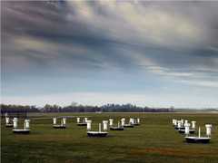
The Arctic Radiation Measurement in Column: Atmosphere-Surface (ARMCAS) was a NASA field investigation that aimed to detect and distinguish between clouds, ice, and snow. ARMCAS involved a single deployment over the Alaska North Slope in June 1995. The University of Washington’s C-131A and NASA’s ER-2 aircraft were equipped with the Cloud Absorption Radiometer (CAR) and MODIS Airborne Simulator (MAS) to gather airborne spectral data, primarily surface-atmosphere bidirectional reflectance. Ground-based bidirectional measurements were also taken using the Portable Apparatus for Rapid Acquisition of Bidirectional Observation of the Land and Atmosphere (PARABOLA) radiometer.
N: 72°N
S: 37°N
W: 165°W
E: 140°W
no campaign DOI available
- MAS Website for ARMCAS
- Overview of airborne spectral measurements for arctic sea and tundra
Additional Notes
Events


