Multiple Altimeter Beam Experimental Lidar
Carbon Cycle & Ecosystems, Climate Variability & Change, Earth Surface & Interior
- 7
- Deployments
2010-12-01 2010-12-12 2011-03-22 2011-04-05 2012-02-22 2012-04-27 2012-09-14 2012-09-28 2013-07-01 2013-07-03 2013-09-18 2013-09-27 2014-07-10 2014-08-02 - 2
- Platforms
- 0
- Data Products
The Campaign
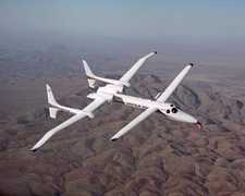
The Multiple Beam Experimental Lidar (MABEL) was a series of test flight campaigns for the MABEL instrument. These flights aimed to support the development of a geophysical algorithm for ICESat-2 before its 2018 launch. From 2010 to 2018, MABEL conducted seven deployments across the Western United States, the Mid-Atlantic, Greenland, and Alaska. The NASA ER-2 and Scaled Composites Proteus aircraft were equipped with the MABEL instruments to gather measurements over ice, sea ice, ocean, and land. Additional sensors, such as the Cloud Physics Lidar (CPL) and Airborne Chromatograph For Atmospheric Trace Species (ACATS), were also used during the test flights. MABEL was funded by the Cryospheric Sciences Program to support the ICESat-2 mission.
N: 83°N
S: 28°N
W: 173°W
E: 8°W
Additional Notes
Repositories
other NASA repository not formally considered a DAAC by ESDS

