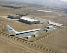
The Airborne Rain Mapping Radar (ARMAR) is an airborne Ku-band Doppler radar developed by the Jet Propulsion Laboratory (JPL). It was designed to simulate the Tropical Rainfall Measuring Mission (TRMM) satellite mission for algorithm development and calibration. ARMAR operates at 13.8 GHz to measure the return power of microwave energy, which is used to determine velocity and reflectivity. It can also serve as a radiometer to measure brightness temperature. ARMAR typically scans across the track at 20-degree angles but can operate at a fixed angle. It has a horizontal resolution of 800 m and a swath width of 9 km at a flight altitude of 12 km.

Instrument Details
- Radar
- Earth Science > Spectral/engineering > Radar > Radar ImageryEarth Science > Spectral/engineering > Radar > Doppler VelocityEarth Science > Spectral/engineering > Microwave > Brightness TemperatureEarth Science > Spectral/engineering > Radar > Return PowerEarth Science > Spectral/engineering > Radar > Radar Reflectivity
- Full Column Profile, Land Surface
- Variable
- 800m
- 13.8 GHz
- https://doi.org/10.1175/1520-0426(1994)011%3C0727:AAARMR%3E2.0.CO;2
Simone Tanelli, Steve Durden
Steve Durden
JPL
NASA
Unpublished
 Douglas DC-8 45 Campaigns · 182 Instruments |  TExas and FLorida UNderflights 1998 Texas, Florida 2 Deployments · 0 Data Products
 Convection and Moisture Experiment 1993—2001 US Atlantic coast, Gulf of Mexico, Caribbean 4 Deployments · 70 Data Products
 Tropical Ocean Global Atmosphere - Coupled Ocean Atmosphere Response Experiment 1992—1993 Western Pacific Ocean, Coral Sea 1 Deployment · 1 Data Product
 Tropical Rain Measuring Mission-Kwajalein Experiment 1999 Kwajalein Atoll, Marshall Islands 1 Deployment · 1 Data Product
|