The Airborne Visible/Infrared Imaging Spectrometer - Classic (AVIRIS-C) is a passive imaging spectrometer developed at the Jet Propulsion Laboratory (JPL). It collects visible and infrared images across 224 spectral channels spanning 380 to 2510 nm. It has a horizontal resolution of 20 m and a swath width of 12 km at an altitude of 20 km. It operates at a scan rate of 12 Hz. AVIRIS-C has been replaced by AVIRIS-Next Generation (AVIRIS-NG), but it is still in use.
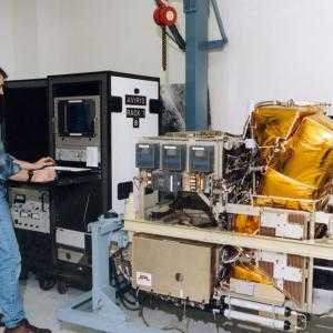

Instrument Details
- Spectrometer/Radiometer
- Earth Science > Spectral/engineering > Visible Wavelengths > Visible ImageryEarth Science > Spectral/engineering > Infrared Wavelengths > Infrared ImageryEarth Science > Spectral/engineering > Visible Wavelengths > Visible RadianceEarth Science > Spectral/engineering > Infrared Wavelengths > Infrared Radiance
- Land Surface
- 12 Hz
- 20 m
- 119.4- 788.9 THz
- https://doi.org/10.1016/S0034-4257(98)00064-9
Robert O. Green
Robert O. Green
JPL
NASA
- Global Hydrology Resource Center DAAC (GHRC)
- Oak Ridge National Laboratory DAAC (ORNL)
other NASA repository not formally considered a DAAC by ESDS
 NASA Earth Resources-2 Aircraft 63 Campaigns · 109 Instruments |  Student Airborne Research Program 2009—2026 Southern California, Virginia Ongoing 19 Deployments · 25 Data Products
 Boreal Ecosystem-Atmosphere Study 1994—1996 Boreal forests of central Canada 2 Deployments · 303 Data Products
OTTER Oregon Transect Ecosystem Research Project 1989—1991 western coniferous forest in Oregon 3 Deployments · 14 Data Products
 Fire Influence on Regional to Global Environments and Air Quality 2019 Northwestern and Southeastern US 1 Deployment · 27 Data Products
 Chesapeake Lighthouse and Aircraft Measurements for Satellites 2001 Chesapeake Bay, Atlantic Ocean 1 Deployment · 5 Data Products
 CO2 and Methane Experiment 2014—2015 Southern California 3 Deployments · 5 Data Products
 GOES-R Post Launch Test 2017 Continental United States 1 Deployment · 19 Data Products
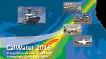 CalWater 2015 California, Sierra Nevada Range 1 Deployment · 0 Data Products
PROVE Prototype Validation Exercise 1997 Jornada Experimental Range near Las Cruces, New Mexico 1 Deployment · 4 Data Products
HyspIRI Airborne Hyperspectral Infrared Imager Preparatory Airborne Campaign 2013—2018 Southern California, Western Nevada, Hawaii 15 Deployments · 16 Data Products
WDTS Western Diversity Time Series 2020—2026 Southern California, Nevada, Pacific Ocean Ongoing 6 Deployments · 6 Data Products
SMEX Soil Moisture Experiment 2002—2005 Iowa, Oklahoma, Georgia, Alabama, Arizona, Sonora, Mexico 4 Deployments · 0 Data Products
 Smoke/Sulfates, Clouds, and Radiation 1993—1995 Mid-Atlantic, Pacific Northwest, Central Brazil 3 Deployments · 6 Data Products
 Geological Earth Mapping Experiment 2023—2026 Southwestern United States, California, Arizona, Nevada, New Mexico Ongoing 4 Deployments · 2 Data Products
 Arctic Radiation Measurement in Column: Atmosphere-Surface 1995 Brooks Range, North Slope, Beaufort Sea, Alaska 1 Deployment · 0 Data Products
ACCP Accelerated Canopy Chemistry Program 1992—1993 Harvard Forest, MA; Blackhawk Island, WI; Howland, ME; Gainesville, FL; Jasper Ridge, CA; Dunnigan, CA; Pleasant Grove, CA 1 Deployment · 6 Data Products
|
Filter data products from this instrument by specific campaigns, platforms, or formats.