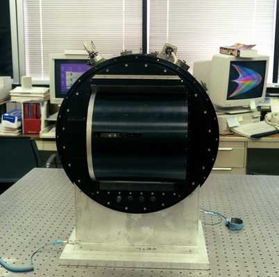
The Airborne Multi-angle Imaging SpectroRadiometer (AirMISR) is a passive remote sensor with a pushbroom design, developed by the Jet Propulsion Laboratory (JPL). AirMISR captures visible and infrared images similar to those from the MISR instrument on the Terra satellite. It collects data with a single camera at nine viewing angles and operates in four spectral bands: 443 nm, 555 nm, 670 nm, and 865 nm. AirMISR has an approximately 11 km swath width and an instantaneous field of view of 7 m x 6 m at nadir. It is typically flown on the NASA ER-2 aircraft because of its high operating altitude of 20 km.


Instrument Details
- Spectrometer/Radiometer
- Earth Science > Spectral/engineering > Visible Wavelengths > Visible ImageryEarth Science > Spectral/engineering > Infrared Wavelengths > Infrared ImageryEarth Science > Land Surface > Topography
- Lower Stratosphere
- 64 Hz
- 7 m x 6 m
- 672 THz, 538 THz, 447 THz, 346 THz
- Currently unavailable
Dave Diner
Dave Diner
JPL
EOS Project Science Office
 NASA Earth Resources-2 Aircraft 63 Campaigns · 109 Instruments |  Southern African Regional Science Initiative 1999—2001 Southern Africa 4 Deployments · 110 Data Products
 Chesapeake Lighthouse and Aircraft Measurements for Satellites 2001 Chesapeake Bay, Atlantic Ocean 1 Deployment · 5 Data Products
 First International Satellite Cloud Climatology Project (ISCCP) Regional Experiment 1986—1998 Central and Midwest United States, California Coast, Northwest Africa, Alaska 5 Deployments · 131 Data Products
 Wisconsin Snow and Cloud Terra 2000 Experiment 2000 Upper Midwest, Great Lakes, Canada, Wisconsin 1 Deployment · 0 Data Products
|