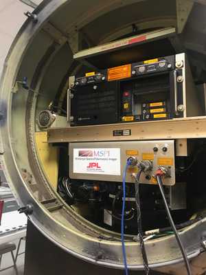
The Airborne Multiangle SpectroPolariMetric Imager (AirMSPI) is a passive, airborne pushbroom camera developed by the Jet Propulsion Laboratory (JPL) in collaboration with engineers from the University of Arizona and the University of Texas. AirMSPI operates across eight spectral bands (355, 380, 445, 470, 555, 660, 865, 935 nm) to provide multiangle radiance and linear polarization imagery, which can be used to determine aerosol and cloud microphysical properties. AirMSPI has a spatial resolution of 10 to 25 meters, depending on the scan mode, and typically captures images at 23 Hz. It was designed to be mounted on the nose of NASA’s ER-2 aircraft and has been used in several aerosol and cloud research missions.


Instrument Details
- Spectrometer/Radiometer
- Earth Science > Atmosphere > Aerosols > Aerosol Optical Depth/thicknessEarth Science > Spectral/engineering > Ultraviolet Wavelengths > Ultraviolet RadianceEarth Science > Atmosphere > Clouds > Cloud Microphysics > Cloud Optical Depth/thicknessEarth Science > Spectral/engineering > Visible Wavelengths > Visible RadianceEarth Science > Atmosphere > Aerosols > Aerosol Particle PropertiesEarth Science > Atmosphere > Clouds > Cloud MicrophysicsEarth Science > Atmosphere > Clouds > Cloud Microphysics > Cloud Droplet Concentration/size
- Full Column Profile
- 23 Hz
- 10-25 m
- 845 THz, 789 THz, 674 THz, 638 THz, 541 THz, 455 THz, 347 THz, 321 THz
- https://doi.org/10.1364/AO.57.004499
David J. Diner
David J. Diner
JPL, University of Arizona, University of Texas
NASA Instrument Incubator Program, Airborne Instrument Technology Transition Program, Earth Science Research Program


