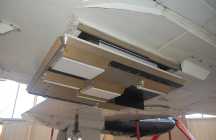
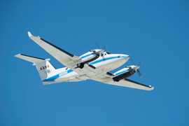
The Air Surface Water and Ocean Topography (AirSWOT) is an airborne instrument suite developed to support calibration for the SWOT satellite mission. AirSWOT consists of three components: Ka-band SWOT Phenomenology Airborne Radar (KaSPAR), Digital Camera System, and Precision Inertial Motion Units (IMU). The KaSPAR — the main element of AirSWOT — collects across-track interferometric data to produce digital elevation models over land and water surfaces. It operates at 35.75 GHz and has a spatial resolution of 3.6 m.


Instrument Details
- Radar
- Earth Science > Land Surface > Topography > Terrain ElevationEarth Science > Spectral/engineering > Radar > Radar ImageryEarth Science > Land Surface > TopographyEarth Science > Spectral/engineering > RadarEarth Science > Spectral/engineering > Radar > Radar BackscatterEarth Science > Land Surface > Topography > Terrain Elevation > Digital Elevation/terrain Model (dem)Earth Science > Terrestrial Hydrosphere > Surface Water
- Land Surface
- Variable
- 3.6 m
- 35.75 GHz
- Currently unavailable
Ernesto Rodriguez, Delwyn Moller
Ernesto Rodriguez, Delwyn Moller
Remote Sensing Solutions (RSS)
NASA
Currently unavailable
 Beechcraft B-200 King Air 39 Campaigns · 84 Instruments |  Delta Exchange 2021—2023 Atchafalaya and Terrebonne basins of the Mississippi River Delta 2 Deployments · 68 Data Products
 Arctic-Boreal Vulnerability Experiment 2017—2026 Alaska, Northwestern Canada Ongoing 6 Deployments · 130 Data Products
|
Filter data products from this instrument by specific campaigns, platforms, or formats.