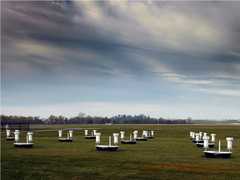
The University of Basilicata Lidar System (BASIL) is a ground-based Raman lidar located in Potenza, Italy, developed by the Department of Environmental Engineering and Physics at the University of Basilicata. It measures atmospheric temperature and water vapor mixing ratio using the rotational Raman lidar technique. BASIL also measures aerosol backscatter, extinction, and depolarization. It operates at wavelengths of 355 nm, 532 nm, and 1064 nm and can collect data both day and night. BASIL has a typical spatial resolution of 30 m and a temporal resolution of 1 minute.

Instrument Details
- Lidar
- Earth Science > Atmosphere > Atmospheric TemperatureEarth Science > Atmosphere > AerosolsEarth Science > Atmosphere > Aerosols > Aerosol ExtinctionEarth Science > Atmosphere > Atmospheric Water VaporEarth Science > Spectral/engineering > Lidar > Lidar BackscatterEarth Science > Atmosphere > Atmospheric Water Vapor > Water Vapor Indicators > Humidity > Relative HumidityEarth Science > Atmosphere > Atmospheric Water Vapor > Water Vapor Profiles > Water Vapor Mixing Ratio ProfilesEarth Science > Spectral/engineering > Lidar > Lidar Depolarization RatioEarth Science > Atmosphere > Aerosols > Aerosol Backscatter
- Full Column Profile
- 1 minute
- 30 m
- 282 THz, 564 THz, 844 THz
- https://doi.org/10.1175/2009JTECHA1253.1
Paolo Girolamo
Paolo Girolamo
University of Basilicata
Currently unavailable
Unpublished
 Field Site Stationary 76 Campaigns · 175 Instruments |  Hydrological Cycle in Mediterranean Experiment 2012 The Mediterranean 1 Deployment · 3 Data Products
|