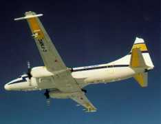
The CCRS-SAR was an airborne synthetic aperture radar (SAR) operated by the Canada Center for Remote Sensing (CCRS) from the mid-1980s until 1996. It featured two radars operating in the C-band (5.3 GHz) and X-band (9.25 GHz). Both radars had dual-channel receivers and dual-polarized antennas, collecting radar images of land, sea ice, and ocean surfaces. The C-band radar had a 3 dB range resolution of 5.7 m in high-resolution mode, while the X-band radar had a range resolution of 4.8 m. CCRS-SAR had a slant-range swath width of 16.4 km and an azimuth resolution of 6 m in high-resolution mode.

Instrument Details
- Radar
- Earth Science > Spectral/engineering > Radar > Radar ImageryEarth Science > Spectral/engineering > Radar
- Full Column Profile
- Variable
- 5.7 m (C-band), 4.8 m (X-band)
- 5.30 GHz, 9.25 GHz
- https://doi.org/10.1109/36.101371
Charles Livingstone
Currently unavailable
CCRS
Currently unavailable
data center outside NASA
 Convair-580 8 Campaigns · 45 Instruments |  Boreal Ecosystem-Atmosphere Study 1994—1996 Boreal forests of central Canada 2 Deployments · 303 Data Products
|