The CU LIDAR Profilometer and Imaging System (CULPIS) is an airborne lidar mapping system developed at the University of Colorado at Boulder. It is designed to map land and sea ice surface topography and elevation from uncrewed aerial systems (UAS). It consists of a lidar system, an inertial measurement unit (IMU), a global positioning system (GPS), and digital cameras. The lidar system within CULPIS operates at 905 nm and has a measurement rate of 400 Hz. At a flight altitude of 200 m above ground level (AGL) and a flight speed of 30 meters per second, it has a lidar footprint of 60 cm and an along-track spacing of 7.5 cm.

Instrument Details
- Lidar
- Earth Science > Terrestrial Hydrosphere > Glaciers/ice Sheets > Glacier Topography/ice Sheet TopographyEarth Science > Land Surface > Topography > Terrain ElevationEarth Science > Cryosphere > Glaciers/ice Sheets > Glacier Topography/ice Sheet TopographyEarth Science > Spectral/engineering > LidarEarth Science > Oceans > Sea Ice > Sea Ice ElevationEarth Science > Land Surface > TopographyEarth Science > Cryosphere > Sea Ice > Sea Ice Elevation
- Sea/Ocean/Water Surface, Land Surface
- 400 Hz
- 60 cm at 200 m AGL
- 331.3 THz
- Currently unavailable
Ian Crocker
Ian Crocker
University of Colorado
NASA
Unpublished
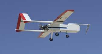
 Sensor Integrated Environmental Remote Research Aircraft 2 Campaigns · 14 Instruments |  Characterization of Arctic Sea Ice Experiment 2009 Svalbard archipelago of Norway 1 Deployment · 0 Data Products
 Marginal Ice Zone Ocean and Ice Observations and Processes Experiment 2013 Southern Beaufort Sea, Prudhoe Bay, Alaska 1 Deployment · 0 Data Products
| ||||||||
 InSitu ScanEagle 1 Campaign · 6 Instruments |  Marginal Ice Zone Ocean and Ice Observations and Processes Experiment 2013 Southern Beaufort Sea, Prudhoe Bay, Alaska 1 Deployment · 0 Data Products
|