The Conical Scanning Millimeter-wave Imaging Radiometer (CoSMIR) is an airborne imaging radiometer designed to validate the Special Sensor Microwave Imager/Sounder (SSMIS). CoSMIR operates across nine spectral channels spanning 50-183 GHz to measure microwave brightness temperature. At an altitude of 20 km at nadir, it has a surface footprint resolution of 1.4 km by 1.4 km. CoSMIR can perform both conical and cross-tracking scanning.
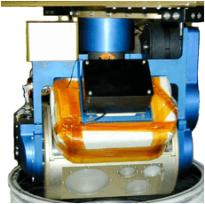

Instrument Details
- Spectrometer/Radiometer
- Earth Science > Spectral/engineering > Microwave > Brightness TemperatureEarth Science > Spectral/engineering > Microwave > Microwave Radiance
- Land Surface
- 2-3 s
- 1.4 km x 1.4 km
- 50-183 GHz
- https://doi.org/10.1109/IGARSS.2001.976672
Rachael Kroodsma
Rachael Kroodsma
Currently unavailable
NASA's Defense Meteorological Satellite Program (DMSP)
Filter data products from this instrument by specific campaigns, platforms, or formats.
CAMPAIGNS
PLATFORMS
FORMATS
