The Configurable Scanning Submillimeter-wave Instrument/Radiometer (CoSSIR) is an airborne imaging radiometer designed to measure ice clouds. It measures brightness temperature across 16 channels spanning 183-874 GHz. These measurements determine ice cloud properties, water vapor profiles, and snowfall rates. CoSSIR has a surface footprint of 1.5 km at nadir from an altitude of 20 km. It has a scan cycle of 4.6 seconds.
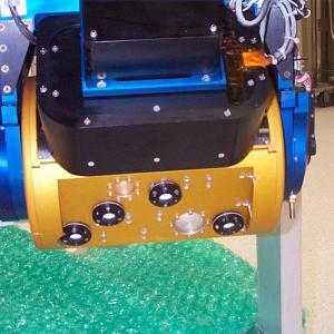

Instrument Details
- Spectrometer/Radiometer
- Earth Science > Atmosphere > Atmospheric Water Vapor > Water Vapor ProfilesEarth Science > Spectral/engineering > Microwave > Brightness TemperatureEarth Science > Atmosphere > Clouds > Tropospheric/high-level Clouds (observed/analyzed) > Cirrus/systems > Cirrus Cloud Systems
- Full Column Profile, Troposphere
- 4.6 s
- 1.5 km
- 183-874 GHz
- Currently unavailable
Rachael Kroodsma
Rachael Kroodsma
GSFC
NASA
Currently unavailable
Unpublished
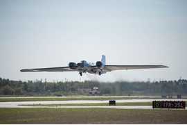 NASA WB-57 17 Campaigns · 84 Instruments |  Costa Rica Aura Validation Experiment 2006 Costa Rica 1 Deployment · 0 Data Products
| ||||||||||||||||||||
 NASA Earth Resources-2 Aircraft 63 Campaigns · 109 Instruments |  Cirrus Regional Study of Tropical Anvils and Cirrus Layers Florida Area Cirrus Experiment 2002 Southern Florida 1 Deployment · 0 Data Products
 Tropical Composition, Cloud and Climate Coupling 2007 Costa Rica, tropical Eastern Pacific 1 Deployment · 2 Data Products
 Investigation of Microphysics and Precipitation for Atlantic Coast-Threatening Snowstorms 2020—2023 Eastern United States 3 Deployments · 73 Data Products
 Airborne Lightning Observatory for FEGS and TGFs 2023 Florida, Gulf of Mexico, Central America, Caribbean Sea 1 Deployment · 5 Data Products
|
Filter data products from this instrument by specific campaigns, platforms, or formats.