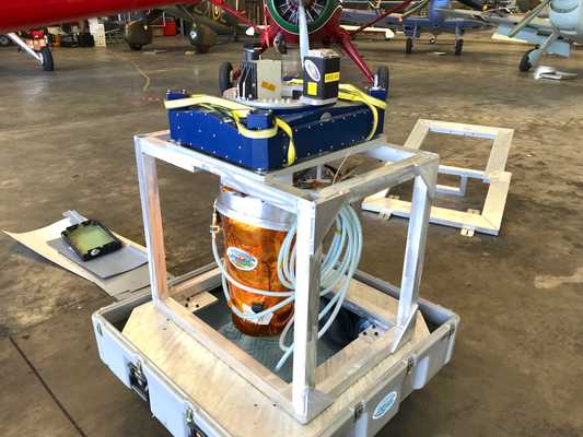
The Hyperspectral Thermal Emissions Spectrometer (HyTES) is an airborne pushbroom imaging spectrometer developed by the Jet Propulsion Laboratory (JPL). It was designed to support the Hyperspectral Infrared Imager (HyspIRI) missions and has been used in several research missions since 2012. HyTES provides high spatial and spectral resolution measurements of brightness temperature, emissivity, and land surface temperature. It operates across 256 spectral channels spanning 7.5 to 12 µm and has an integration time of 30 ms. At a flight altitude of 4 km, HyTES has a horizontal resolution of 7 m and a swath width of 3.6 km. HyTES was funded through NASA’s Earth Science Technology Office (ESTO) Instrument Incubator Program (IIP).


Instrument Details
- Spectrometer/Radiometer
- Earth Science > Land Surface > Surface Thermal Properties > Land Surface TemperatureEarth Science > Atmosphere > Atmospheric Radiation > EmissivityEarth Science > Spectral/engineering > Infrared Wavelengths > Brightness Temperature
- Land Surface, Troposphere
- 30 ms
- 7 m
- 25-40 THz
- https://doi.org/10.1109/AERO.2011.5747394
Simon Hook, Bjorn Eng
Simon Hook
Jet Propulsion Laboratory
NASA
other NASA repository not formally considered a DAAC by ESDS
 NASA Earth Resources-2 Aircraft 63 Campaigns · 109 Instruments |  Fire Influence on Regional to Global Environments and Air Quality 2019 Northwestern and Southeastern US 1 Deployment · 27 Data Products
HyspIRI Airborne Hyperspectral Infrared Imager Preparatory Airborne Campaign 2013—2018 Southern California, Western Nevada, Hawaii 15 Deployments · 16 Data Products
WDTS Western Diversity Time Series 2020—2026 Southern California, Nevada, Pacific Ocean Ongoing 6 Deployments · 6 Data Products
 Geological Earth Mapping Experiment 2023—2026 Southwestern United States, California, Arizona, Nevada, New Mexico Ongoing 4 Deployments · 2 Data Products
| ||||||||||||||||||||||||||||||||||||||||||||||||||||||||||||
 DeHavilland DHC-6-300 Twin Otter 23 Campaigns · 85 Instruments | SHIFT Surface Biology and Geology (SBG) High-Frequency Time Series 2022 Santa Barbara County, California, Pacific Ocean 1 Deployment · 17 Data Products
| ||||||||||||||||||||||||||||||||||||||||||||||||||||||||||||
 Gulfstream-V 8 Campaigns · 38 Instruments |  Biodiversity Survey of the Cape 2023 South Africa’s Greater Cape Floristic Region (GCFR) 1 Deployment · 5 Data Products
|
Filter data products from this instrument by specific campaigns, platforms, or formats.