The Lightning Mapping Array (LMA) is a ground-based network of lightning-detection sensors. An LMA network includes very high-frequency (VHF) antennas, GPS receivers, and processing systems that determine the location, timing, and structure of total lightning. LMA has a horizontal spatial resolution of about 6-12 meters, a vertical resolution of roughly 20-30 meters, and a spatial coverage of approximately 200 km from the network center. It typically samples at 10 µs with about 95% accuracy within 100 km of the network center. LMA networks are located in several areas, including Oklahoma, New Mexico, North Alabama, West Texas, Colorado, and Southern Ontario.
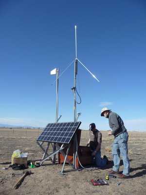

Instrument Details
- Magnetic/Electric
- Earth Science > Atmosphere > Atmospheric Electricity > LightningEarth Science > Atmosphere > Atmospheric Electricity
- Land Surface
- 10 μs, 80-100 μs
- 6-12 m (horizontal), 20-30 m (vertical)
- Variable
- Currently unavailable
Bill Rison, Paul Krehbiel, Ron Thomas
Bill Rison, Paul Krehbiel, Ron Thomas
New Mexico Tech
NSF, U.S. Air Force Office of Scientific Research, New Mexico Universities Collaborative Research Program
 Permanent Land Site Stationary 63 Campaigns · 100 Instruments |  Deep Convective Clouds & Chemistry 2012 Northeastern Colorado, West Texas to Central Oklahoma, Northern Alabama 1 Deployment · 19 Data Products
 GOES-R Post Launch Test 2017 Continental United States 1 Deployment · 19 Data Products
 Tropical Cloud Systems and Processes 2005 Costa Rica, Caribbean, Gulf of Mexico, eastern North Pacific 1 Deployment · 14 Data Products
 Airborne Lightning Observatory for FEGS and TGFs 2023 Florida, Gulf of Mexico, Central America, Caribbean Sea 1 Deployment · 5 Data Products
| ||||||||||||||||
 Field Site Stationary 76 Campaigns · 175 Instruments |  Hydrological Cycle in Mediterranean Experiment 2012 The Mediterranean 1 Deployment · 3 Data Products
|
Filter data products from this instrument by specific campaigns, platforms, or formats.