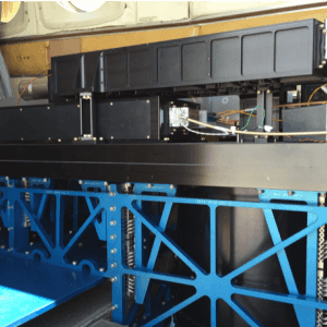
The Multi-function Airborne Raman Lidar (MARLi) is an airborne lidar that collects profile measurements within the planetary boundary layer (PBL). It operates at 355 nm and/or 266 nm to detect Raman lidar signals and measure profiles of temperature, water vapor mixing ratio, aerosols, and clouds. It has a horizontal resolution of approximately 100 m to 1 km and a vertical resolution of 60 cm. MARLi has a measurement sampling rate of 10 Hz.


Instrument Details
- Lidar
- Earth Science > Spectral/engineering > Lidar > Lidar BackscatterEarth Science > Atmosphere > CloudsEarth Science > Atmosphere > Atmospheric Water Vapor > Water Vapor ProfilesEarth Science > Atmosphere > AerosolsEarth Science > Atmosphere > Atmospheric Temperature > Upper Air Temperature > Boundary Layer TemperatureEarth Science > Atmosphere > Atmospheric Water Vapor > Water Vapor Profiles > Water Vapor Mixing Ratio ProfilesEarth Science > Spectral/engineering > Lidar
- Boundary Layer, Full Column Profile
- 10 Hz
- 60 cm (vertical), 100 m-1 km (horizontal)
- 844.5 THz, 1127 THz
- Currently unavailable
Zhien Wang
Zhien Wang
Currently unavailable
NSF
Currently unavailable
data center outside NASA
 P-3 Orion 30 Campaigns · 153 Instruments |  Arctic Radiation-Cloud-Aerosol-Surface Interaction EXperiment 2024 Greenland, Arctic Ocean 2 Deployments · 13 Data Products
|
Filter data products from this instrument by specific campaigns, platforms, or formats.
CAMPAIGNS
PLATFORMS
FORMATS