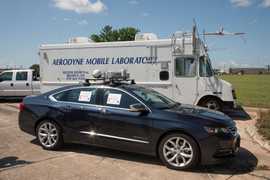
The Mobile Alabama X-Band Radar (MAX) is a truck-mounted dual-polarization radar owned and operated by the University of Alabama in Huntsville (UAH). It is typically deployed to collect radar data on tropical storms, severe weather, and boundary-layer conditions. MAX operates at 9450 MHz with a beam width of 0.95 degrees and a range gate spacing of 125 meters.

Instrument Details
- Radar
- Earth Science > Spectral/engineering > Radar > Radar ReflectivityEarth Science > Spectral/engineering > Radar > Radar ImageryEarth Science > Spectral/engineering > Radar > Doppler VelocityEarth Science > Spectral/engineering > Radar > Radial Velocity > Mean Radial VelocityEarth Science > Spectral/engineering > Radar > Spectrum Width
- Full Column Profile
- Variable
- 125 m
- 9450 MHz
- Currently unavailable
Lawrence Carey
Lawrence Carey
Baron, UAH
UAH, NOAA
Currently unavailable
data center outside NASA
 Vehicle 21 Campaigns · 68 Instruments |  Deep Convective Clouds & Chemistry 2012 Northeastern Colorado, West Texas to Central Oklahoma, Northern Alabama 1 Deployment · 19 Data Products
PECAN Plains Elevated Convection at Night 2015 Great Plains, United States 1 Deployment · 0 Data Products
|