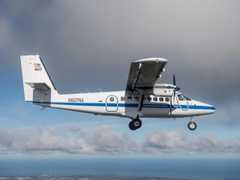
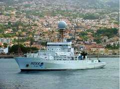
The Micro-pulse Doppler (MicroDop) Lidar is a scanning Doppler lidar system operated by the NOAA Chemical Sciences Laboratory. It measures lidar backscatter at approximately 1.5 μm to provide profiles of horizontal winds and aerosol backscatter intensity (ABI). MicroDop has a vertical resolution of 33.6 m, a maximum range of 7 km, and a typical temporal resolution of 2 Hz. It can be deployed on aircraft, research vessels, and ground-based platforms.

Instrument Details
- Lidar
- Earth Science > Atmosphere > Atmospheric Winds > Wind ProfilesEarth Science > Spectral/engineering > Lidar > Lidar BackscatterEarth Science > Spectral/engineering > Platform Characteristics > Line Of Sight VelocityEarth Science > Atmosphere > AerosolsEarth Science > Atmosphere > Aerosols > Aerosol BackscatterEarth Science > Atmosphere > Atmospheric Winds > Wind Profiles > Line Of Sight Winds
- Full Column Profile
- 2 Hz
- 33.6 m
- 193 THz
- Currently unavailable
Alan Brewer
Alan Brewer
NOAA CSL
Currently unavailable
data center outside NASA
 DeHavilland DHC-6-300 Twin Otter 23 Campaigns · 85 Instruments |  Fire Influence on Regional to Global Environments and Air Quality 2019 Northwestern and Southeastern US 1 Deployment · 27 Data Products
 Atmospheric Emissions and Reactions Observed from Megacities to Marine Areas 2023 Urban regions across the western and eastern United States 1 Deployment · 0 Data Products
| ||||||||
 R/V Ronald H. Brown 4 Campaigns · 51 Instruments | ATOMIC Atlantic Tradewind Ocean-Atmosphere Mesoscale Interaction Campaign 2020 Tropical North Atlantic east of Barbados 1 Deployment · 1 Data Product
|
Filter data products from this instrument by specific campaigns, platforms, or formats.