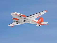
The Photon Counting Lidar (PCL) is an airborne lidar system developed by Sigma Space Corporation. Rather than capturing the full return waveform like traditional lidars, it detects and counts individual photons returned from the laser pulse, enabling finer resolution and higher repetition rates. It is primarily used for topographic and bathymetric mapping. PCL operates at 532 nm, scans the terrain at 18.5 Hz, and achieves a spatial resolution of 10 cm per photon at a typical survey altitude of 800 meters.

Instrument Details
- Lidar
- Earth Science > Spectral/engineering > LidarEarth Science > Terrestrial Hydrosphere > Glaciers/ice Sheets > Glacier Topography/ice Sheet TopographyEarth Science > Land Surface > Topography > Terrain ElevationEarth Science > Cryosphere > Glaciers/ice Sheets > Glacier Topography/ice Sheet TopographyEarth Science > Terrestrial Hydrosphere > Glaciers/ice Sheets > Glacier Elevation/ice Sheet ElevationEarth Science > Cryosphere > Glaciers/ice Sheets > Glacier Elevation/ice Sheet ElevationEarth Science > Land Surface > Topography
- Land Surface
- 18.5 Hz
- 10 cm
- 563.5 THz
- Currently unavailable
Currently unavailable
Currently unavailable
Sigma Space Corporation
Currently unavailable
Currently unavailable
 Basler BT-67 4 Campaigns · 13 Instruments |  Operation IceBridge 2009—2021 Greenland, Antarctica, Alaska, Arctic Sea 37 Deployments · 79 Data Products
|
Filter data products from this instrument by specific campaigns, platforms, or formats.
CAMPAIGNS
PLATFORMS
FORMATS