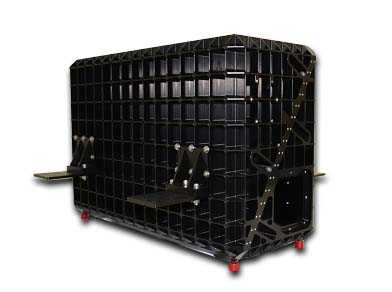
The Pushbroom Imager for Cloud and Aerosol Research and Development (PICARD) is an airborne imaging spectrometer operated by the Airborne Sensor Facility (ASF) at Ames Research Center (ARC), with science and management support from Goddard Space Flight Center (GSFC). It provides visible near-infrared (VNIR) and short-wave infrared (SWIR) imagery to support atmospheric research and validate satellite retrievals. PICARD operates across 205 spectral bands spanning 400-2500 nm. It has a spatial resolution of 5-50 m and a swath width of 2-16 km, depending on altitude. PICARD has a frame rate of 6.25-100 Hz, depending on integration time, and a field of view of 50 degrees.


Instrument Details
- Spectrometer/Radiometer
- Earth Science > Spectral/engineering > Infrared Wavelengths > Infrared RadianceEarth Science > Spectral/engineering > Visible Wavelengths > Visible ImageryEarth Science > Spectral/engineering > Visible Wavelengths > Visible RadianceEarth Science > Spectral/engineering > Infrared Wavelengths > Infrared Imagery
- Land Surface, Troposphere
- 6.25-100 Hz
- 5-50 m
- 120-750 THz
- Currently unavailable
Kerry Meyer
Kerry Meyer
Currently unavailable
Currently unavailable
Currently unavailable
Unpublished
 NASA Earth Resources-2 Aircraft 63 Campaigns · 109 Instruments | WDTS Western Diversity Time Series 2020—2026 Southern California, Nevada, Pacific Ocean Ongoing 6 Deployments · 6 Data Products
 Geological Earth Mapping Experiment 2023—2026 Southwestern United States, California, Arizona, Nevada, New Mexico Ongoing 4 Deployments · 2 Data Products
 Plankton, Aerosol, Cloud, ocean Ecosystem Postlaunch Airborne eXperiment 2024 Southern and Central California 1 Deployment · 14 Data Products
|
Filter data products from this instrument by specific campaigns, platforms, or formats.