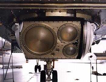
The Polarimetric Scanning Radiometer (PSR) is an airborne passive microwave imaging radiometer developed by Georgia Tech and NOAA. It captures polarimetric microwave emission images of Earth to analyze ocean and land surface features, precipitation, ice, and clouds. PSR operates across four microwave channels: 10.7 GHz, 18.7 GHz, 37 GHz, and 89 GHz. The PSR/A version includes an additional dual-polarimetric channel at 21.5 GHz. Operating at an altitude of 22,000 feet above sea level, PSR has a spatial resolution of 0.3 to 2.2 km, depending on the frequency band and scan mode.


Instrument Details
- Spectrometer/Radiometer
- Earth Science > Spectral/engineering > Microwave > Microwave ImageryEarth Science > Spectral/engineering > Microwave > Brightness Temperature
- Land Surface, Troposphere
- 10 s
- 0.3-2.2 km
- 10.7 GHz, 18.7 GHz, 21.5 GHz, 37 GHz, 89 GHz
- https://directory.eoportal.org/other-space-activities/psr#calibration
Al Gasiewski
Al Gasiewski
Georgia Tech, NOAA
NASA
Filter data products from this instrument by specific campaigns, platforms, or formats.
CAMPAIGNS
PLATFORMS


