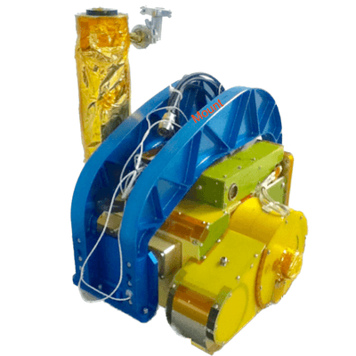
The Research Scanning Polarimeter (RSP) is an airborne, passive polarimeter developed by SpecTIR Corporation. It measures total radiance and linear polarization across nine spectral bands spanning the visible and infrared wavelengths (410-2250 nm). These measurements can be used to determine aerosol and cloud properties. RSP has a time resolution of 0.8 seconds, a field of view of 14 mrad, and a horizontal resolution of approximately 100 meters at an altitude of 5 km.

Instrument Details
- Spectrometer/Radiometer
- Earth Science > Atmosphere > Aerosols > Aerosol BackscatterEarth Science > Atmosphere > Aerosols > Aerosol ExtinctionEarth Science > Atmosphere > Aerosols > Aerosol Forward ScatterEarth Science > Atmosphere > Aerosols > Aerosol Optical Depth/thicknessEarth Science > Atmosphere > Aerosols > Aerosol Particle PropertiesEarth Science > Atmosphere > Aerosols > Aerosol RadianceEarth Science > Atmosphere > AerosolsEarth Science > Atmosphere > Clouds > Cloud Droplet DistributionEarth Science > Atmosphere > Clouds > Cloud Microphysics > Cloud Droplet Concentration/sizeEarth Science > Atmosphere > Clouds > Cloud Microphysics > Cloud Optical Depth/thicknessEarth Science > Atmosphere > Clouds > Cloud MicrophysicsEarth Science > Atmosphere > Clouds > Cloud Properties > Cloud AsymmetryEarth Science > Atmosphere > Clouds > Cloud Properties > Cloud Top HeightEarth Science > Atmosphere > Clouds > Cloud PropertiesEarth Science > Atmosphere > CloudsEarth Science > Spectral/engineering > Infrared Wavelengths > Infrared RadianceEarth Science > Spectral/engineering > Visible Wavelengths > Visible Radiance
- Land Surface, Troposphere
- 0.8 s
- 100 m
- 133-731 THz
- https://doi.org/10.1117/12.366329
Brian Cairns
Brian Cairns
SpecTIR Corporation
Currently unavailable
Filter data products from this instrument by specific campaigns, platforms, or formats.
CAMPAIGNS
PLATFORMS
FORMATS

