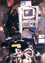
The Scanning Lidar Imager of Canopies by Echo Recovery (SLICER) is an airborne and ground-based lidar system. SLICER provides measurements of canopy characteristics, including canopy height, vertical structure, and ground elevation. It has a horizontal resolution of 10 meters and a vertical resolution of 1 meter, and it operates at 1.06 microns. SLICER can deliver high-resolution measurements beneath dense canopies and in vegetated areas.


Instrument Details
- Lidar
- Earth Science > Biosphere > Vegetation > Canopy CharacteristicsEarth Science > Land Surface > Topography > Topographic EffectsEarth Science > Land Surface > Topography > Terrain ElevationEarth Science > Spectral/engineering > Lidar > Lidar BackscatterEarth Science > Land Surface > TopographyEarth Science > Biosphere > Vegetation
- Land Surface
- 80 Hz
- 10 m (horizontal), 1 m (vertical)
- 282 THz
- https://ntrs.nasa.gov/api/citations/20010021953/downloads/20010021953.pdf
J. Bryan Blair
David Harding
NASA Goddard Space Flight Center
Goddard Director's Discretionary Fund, NASA's Solid Earth and Natural Hazards Program
Currently unavailable
 C-130 Hercules 17 Campaigns · 96 Instruments |  Boreal Ecosystem-Atmosphere Study 1994—1996 Boreal forests of central Canada 2 Deployments · 303 Data Products
|
Filter data products from this instrument by specific campaigns, platforms, or formats.
CAMPAIGNS
PLATFORMS