The San Jose State University (SJSU) Wildfire Imaging System (SWIS) is an airborne imaging system operated by the SJSU Wildfire Interdisciplinary Research Center (WIRC). It uses mid-wave infrared (MWIR) and long-wave infrared (LWIR) optical sensors to capture multispectral images of wildfires. The MWIR camera, made by Telops, has a spectral range of 3-5 μm and a resolution of 640x512 pixels. The LWIR camera, made by Workwell, covers a spectral range of 7.5-13.5 μm and has a resolution of 640x512 pixels. The SWIS camera system provides imagery at 30 Hz, with a ground sampling distance of 2-3 meters and a swath width of 1.3-2 km.

Instrument Details
- Optical/Photon
- Earth Science > Spectral/engineering > Visible Wavelengths > Visible ImageryEarth Science > Spectral/engineering > Infrared Wavelengths > Infrared ImageryEarth Science > Human Dimensions > Natural Hazards > Wildfires
- Land Surface
- 30 Hz
- 640x512 pixels
- 60-100 Hz, 22-40 THz
- Currently unavailable
Craig Clements
Craig Clements, Miguel Valero
Telops, Workwell
Currently unavailable
Currently unavailable
data center outside NASA
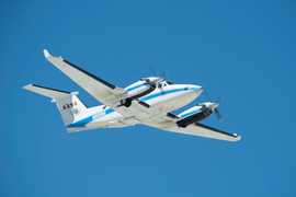
 Beechcraft B-200 King Air 39 Campaigns · 84 Instruments |  FireSense 2023—2027 Western United States, Southeastern United States, California, Montana, Arizona, Utah, Colorado, Alabama, Florida, Georgia, Mississippi, Texas, Oklahoma Ongoing 3 Deployments · 1 Data Product
|