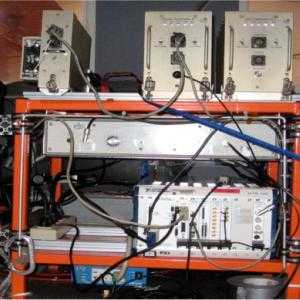
The Warm Ice Sounding Explorer (WISE) is an airborne radar developed by the Jet Propulsion Laboratory (JPL) and the University of California Irvine (UCI). It is a low-frequency radar (2.5 MHz) that penetrates temperate ice to measure glacier and ice sheet thickness. It was designed based on the satellite instrument Mars Advanced Radar for Subsurface and Ionosphere Sounding (MARSIS). WISE operates at altitudes of 250-1000 meters and has a sampling frequency of 20 MHz. It has a vertical resolution of 30 meters in the air and 17 meters in the ice.


Instrument Details
- Radar
- Earth Science > Cryosphere > Glaciers/ice Sheets > Glacier Thickness/ice Sheet ThicknessEarth Science > Terrestrial Hydrosphere > Glaciers/ice Sheets > Glacier Thickness/ice Sheet ThicknessEarth Science > Spectral/engineering > Radar
- Land Surface
- 20 MHz
- 30m (air), 17m (ice)
- 2.5 MHz
- Currently unavailable
Yonggyu Gim, Eric Rignot
Yonggyu Gim
JPL, UCI
NASA
Currently unavailable
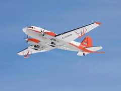
 Basler BT-67 4 Campaigns · 13 Instruments |  Operation IceBridge 2009—2021 Greenland, Antarctica, Alaska, Arctic Sea 37 Deployments · 79 Data Products
| ||||||||||||||||||||||||||||||||||||||||||||||||||||||||||||||||||||||||||||
 DeHavilland DHC-3 Otter 1 Campaign · 5 Instruments |  Operation IceBridge 2009—2021 Greenland, Antarctica, Alaska, Arctic Sea 37 Deployments · 79 Data Products
|
Filter data products from this instrument by specific campaigns, platforms, or formats.