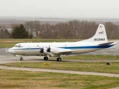
The NOAA Wide Swath Radar Altimeter (WSRA) is an airborne radar system developed by ProSensing. It measures radar backscatter to determine significant wave height, ocean wave spectra, wave topography, and rainfall rate. WSRA is typically flown on NOAA P-3D aircraft for hurricane missions. It operates at 16 GHz with a sampling rate of 10 Hz. WSRA has a spatial resolution of 5.5-8 km along track and 2 km across track, with a total swath width of 3 km.

Instrument Details
- Radar
- Earth Science > Oceans > Ocean Waves > Wave SpectraEarth Science > Oceans > Ocean WavesEarth Science > Oceans > Ocean Waves > Wave HeightEarth Science > Atmosphere > Precipitation > Precipitation RateEarth Science > Spectral/engineering > Radar > Radar BackscatterEarth Science > Oceans > Ocean Waves > Topographic WavesEarth Science > Oceans > Ocean Waves > Significant Wave HeightEarth Science > Oceans > Ocean Waves > Wave Speed/direction
- Sea/Ocean/Water Surface
- 10 Hz
- 5.5-8 km, 2 km
- 16 GHz
- Currently unavailable
Ivan PopStefanija, Christopher Fairall
Ivan PopStefanija, Christopher Fairall
ProSensing
NOAA, CASCA
data center outside NASA
 P-3 Orion 30 Campaigns · 153 Instruments |  CalWater 2015 California, Sierra Nevada Range 1 Deployment · 0 Data Products
ATOMIC Atlantic Tradewind Ocean-Atmosphere Mesoscale Interaction Campaign 2020 Tropical North Atlantic east of Barbados 1 Deployment · 1 Data Product
|