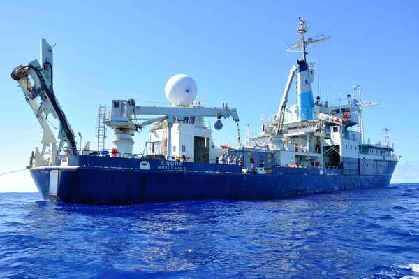
Overview
The R/V Knorr was a research vessel owned by the United States Navy and operated by the Woods Hole Oceanographic Institute (WHOI). It was equipped with heavy equipment, instrument hangers, and laboratories to support a variety of oceanographic research. Typical research voyages could last up to 60 days, cover up to 12,000 nautical miles, and support 22 crew members and 32 scientists. R/V Knorr was decommissioned in 2016.
Online information
Related Campaigns & Instruments
Review the instruments operated on this platform for each of these field campaigns
Slide 1 of 1
SPURS
Salinity Processes in the Upper Ocean Regional Study
2012—2017
Subtropical North Atlantic Ocean, Tropical Eastern Pacific Ocean
view all deployment dates
2 Deployments
· 41 Data Products2012-08-16 | 2013-10-13 |
2016-08-13 | 2017-11-17 |
LI-COR Gas Analyzer is an in situ gas analyzer manufactured by LI-COR. They can be deployed on aircraft, research vessels, vehicles, balloons, and ground-based platforms. They provide measurements of various trace gases such as carbon dioxide (CO2), methane (CH4), nitrous oxide (N2O), and water vapor (H2O). Most models use Optical Feedback-Cavity Enhanced Absorption Spectroscopy (OF-CEAS) to collect measurements. LI-COR gas analyzers have a typical measurement rate of 1 Hz and an operating temperature range of -25 to 45 degrees Celsius.
Earth Science > Atmosphere > Atmospheric Chemistry > Nitrogen Compounds > Ammonia
Earth Science > Atmosphere > Atmospheric Chemistry > Trace Gases/trace Species
Earth Science > Atmosphere > Atmospheric Chemistry > Carbon And Hydrocarbon Compounds > Methane
Earth Science > Atmosphere > Atmospheric Chemistry > Carbon And Hydrocarbon Compounds > Carbon Dioxide
Earth Science > Atmosphere > Atmospheric Chemistry
Earth Science > Atmosphere > Atmospheric Water Vapor
Earth Science > Atmosphere > Atmospheric Water Vapor > Water Vapor Indicators > Water Vapor
Earth Science > Atmosphere > Atmospheric Chemistry > Nitrogen Compounds > Nitrous Oxide
Generic-Atmospheric State (Gen-AtmsState) refers to non-specific instruments on a platform used for measurements of atmospheric state parameters. These are typically in situ sensors that measure temperature, pressure, humidity, and wind speed/direction. Types of atmospheric state instruments include thermometers, hygrometers, barometers, and anemometers.
Earth Science > Atmosphere > Atmospheric Water Vapor
Earth Science > Atmosphere > Atmospheric Pressure
Earth Science > Atmosphere > Atmospheric Water Vapor > Water Vapor Indicators > Humidity
Earth Science > Atmosphere > Atmospheric Temperature > Surface Temperature > Air Temperature
Earth Science > Atmosphere > Atmospheric Winds > Upper Level Winds > Wind Direction
Earth Science > Atmosphere > Atmospheric Winds > Upper Level Winds > Wind Speed
Earth Science > Atmosphere > Atmospheric Pressure > Atmospheric Pressure Measurements
Earth Science > Atmosphere > Atmospheric Winds > Surface Winds > Wind Direction
Earth Science > Atmosphere > Atmospheric Temperature
Earth Science > Atmosphere > Atmospheric Winds > Surface Winds > Wind Speed
Earth Science > Atmosphere > Atmospheric Winds
Conductivity, Temperature, and Depth (CTD) sensors are in situ instrument packages used to measure water depth, pressure, salinity, temperature, and density in the ocean. CTD sensors can be deployed on various water-based platforms such as autonomous underwater vehicles (AUVs), buoys, gliders, or research vessels. When deployed on a vessel, CTD sensors are typically attached to a rosette and then lowered to the seafloor to measure water properties. CTD sensors have a typical sampling rate of 30 Hz and can collect precise measurements at specific water depths based on the researcher's needs.
Earth Science > Oceans > Ocean Pressure > Water Pressure
Earth Science > Oceans > Bathymetry/seafloor Topography > Water Depth
Earth Science > Oceans > Salinity/density > Conductivity
Earth Science > Oceans > Salinity/density > Density
Earth Science > Oceans > Salinity/density > Salinity
Earth Science > Oceans > Ocean Temperature > Water Temperature
Earth Science > Oceans > Salinity/density
Rain gauges are ground-based instruments that measure liquid precipitation amounts directly over a specified period. Different rain gauges, such as tipping buckets and weighing gauges, collect and record data in various ways. Because of their small size and easy setup, rain gauges can be placed in different locations and are often used alongside other precipitation instruments like disdrometers to gather more details, such as precipitation rate and size distribution.
Earth Science > Atmosphere > Precipitation > Liquid Precipitation
Earth Science > Atmosphere > Precipitation > Precipitation Amount
Earth Science > Atmosphere > Precipitation
A thermosalinograph (TSG) is an in situ shipborne instrument used to measure sea surface temperature and conductivity. TSGs are typically mounted near the ship’s seawater intake where they collect continuous measurements. A TSG uses a conductivity cell and a thermistor cell to measure conductivity and temperature from underway vessels. These measurements can be used to derive salinity and other ocean parameters.
Earth Science > Oceans > Ocean Temperature > Sea Surface Temperature
Earth Science > Oceans > Salinity/density > Salinity
Earth Science > Oceans > Salinity/density > Conductivity
Earth Science > Oceans > Salinity/density
Earth Science > Oceans > Ocean Temperature
The Acoustic Doppler Current Profiler (ADCP) is an in situ acoustic sensor used to measure ocean currents. ADCP utilizes the Doppler effect to detect sound waves, providing measurements of the speed and direction of currents throughout the water column. It can be easily mounted on various water platforms such as ships, buoys, and autonomous underwater vehicles (AUVs). Additionally, it can be deployed on the seafloor to deliver profile measurements of ocean currents.
Earth Science > Oceans > Ocean Acoustics
Earth Science > Oceans > Ocean Circulation > Ocean Currents
Accelerometers are in situ sensors that measure the acceleration experienced by an object. Accelerometers utilize electromagnetic sensing to detect the vibration of an object. The force of vibration causes the sensor to produce an electrical charge, indicating how much force was exerted, which can be used to determine the acceleration. Accelerometers are typically used on aircraft when collecting flight navigation information. Accelerometers have also been deployed on research vessels and other water-based platforms such as buoys.
Earth Science > >
Generic-Radiometers refer to non-specific radiometers on a platform. These are typically passive microwave radiometers that measure brightness temperature. Radiometers can be used to retrieve temperature and water vapor profiles, soil moisture content, ocean salinity, precipitation and cloud properties, and vegetation.
Earth Science > Spectral/engineering > Microwave > Brightness Temperature
Salinity Snake is a water-based instrument developed by Earth and Space Research (ESR) to measure sea surface salinity and temperature. It consists of two steel spiral rubber hoses mounted on a boom on the starboard side of the research vessel, positioning the hoses outside its wake. The device collects undisturbed water samples at depths of 1 to 2 cm. These samples are then pumped to a thermosalinograph (TSG) to measure conductivity and sea surface temperature to determine salinity.
Earth Science > Oceans > Salinity/density > Salinity
Earth Science > Oceans > Ocean Temperature > Sea Surface Temperature
Earth Science > Oceans > Salinity/density > Conductivity
Earth Science > Oceans > Salinity/density
Earth Science > Oceans > Ocean Temperature
The Vertical Microstructure Profiler (VMP) is an in situ full ocean-depth profiling system manufactured by Rockland Scientific. It consists of several sensors that collect profile measurements of turbulence, temperature, conductivity, and other ocean parameters. A VMP is deployed from ships and operates autonomously. It can collect profile measurements up to 6000 m in depth. It has a nominal sampling frequency of 512 Hz.
Earth Science > Oceans > Ocean Optics > Turbidity
Earth Science > Oceans > Ocean Pressure > Water Pressure
Earth Science > Oceans > Ocean Pressure
Earth Science > Oceans > Ocean Optics > Fluorescence
Earth Science > Oceans > Salinity/density > Conductivity
Earth Science > Oceans > Ocean Circulation > Turbulence
Earth Science > Oceans > Ocean Chemistry > Oxygen
Earth Science > Oceans > Ocean Temperature
Earth Science > Oceans > Ocean Temperature > Water Temperature
Filter data products from this platform by specific campaigns, instruments, or formats.
Campaigns
CAMPAIGNS▼
Instruments
INSTRUMENTS▼
Formats
FORMATS▼