- 2
- Campaigns
- 4
- Data Products
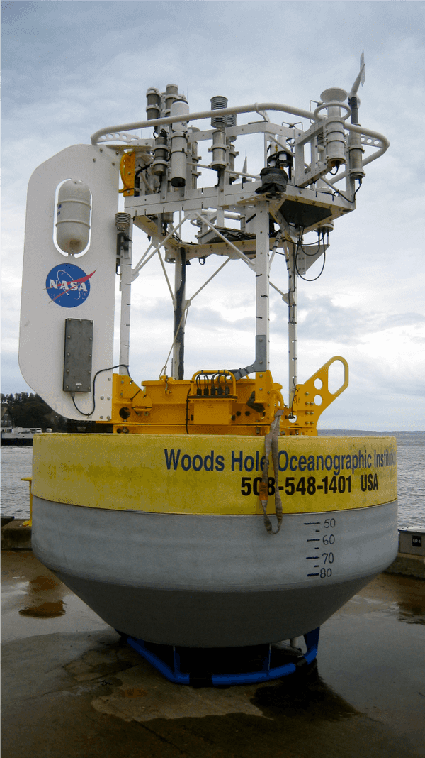
Overview
This description will be added in future versions.
Online information
Related Campaigns & Instruments
Review the instruments operated on this platform for each of these field campaigns
Slide 1 of 3
SPURS
Salinity Processes in the Upper Ocean Regional Study
2012—2017
Subtropical North Atlantic Ocean, Tropical Eastern Pacific Ocean
view all deployment dates
2 Deployments
· 38 Data Products2012-08-16 | 2013-10-13 |
2016-08-13 | 2017-11-17 |
This description will be added in future versions.
Earth Science > Oceans > Salinity/density > Conductivity
Earth Science > Oceans > Salinity/density > Salinity
Earth Science > Oceans > Ocean Temperature
If instrument model information is not available, can use this instrument entry for temperature, pressues, wind speed, wind direction, humidity
Earth Science > >
SPURS
Salinity Processes in the Upper Ocean Regional Study
2012—2017
Subtropical North Atlantic Ocean, Tropical Eastern Pacific Ocean
view all deployment dates
2 Deployments
· 38 Data Products2012-08-16 | 2013-10-13 |
2016-08-13 | 2017-11-17 |
Rain gauges are ground-based instruments that provide in situ measurements of liquid precipitation amounts over a set time. There are multiple types of rain gauges that each collect and record data differently such as the tipping bucket rain gauge and weighing precipitation gauge. Rain gauges can be deployed in various locations due to their relatively small size and easy set-up and are typically colocated with other precipitation instruments such as disdrometers to provide more details about precipitation being collected such as precipitation rate and size distribution.
Earth Science > Atmosphere > Precipitation > Liquid Precipitation
Earth Science > Atmosphere > Precipitation > Precipitation Amount
Earth Science > Atmosphere > Precipitation
This data will be added in future versions
Earth Science > Atmosphere > Atmospheric Radiation
If instrument model or detailed specification information is not available, can use this instrument entry for radiometers of various types (typically microwave-band) that are flown on aircraft.
Earth Science > >
This data will be added in future versions
Earth Science > >
Conductivity, Temperature, and Depth (CTD) sensors are in situ instrument packages that are used to measure water depth, pressure, salinity, temperature, and density in the ocean. CTD sensors can be deployed on various water-based platforms such as autonomous underwater vehicles (AUVs), buoys, gliders, or research vessels. When deployed on a vessel, CTD sensors are typically attached to a rosette and then lowered to the seafloor to measure water properties. CTD sensors have a typical sampling rate of 30 Hz and can collect precise measurements for a specific water depth depending on the researcher's needs.
Earth Science > Oceans > Ocean Pressure > Water Pressure
Earth Science > Oceans > Bathymetry/seafloor Topography > Water Depth
Earth Science > Oceans > Salinity/density > Conductivity
Earth Science > Oceans > Salinity/density > Density
Earth Science > Oceans > Salinity/density > Salinity
Earth Science > Oceans > Ocean Temperature > Water Temperature
Earth Science > Oceans > Salinity/density
If instrument model information is not available, can use this instrument entry for temperature, pressues, wind speed, wind direction, humidity
Earth Science > >
The Acoustic Doppler Current Profiler (ADCP) is an in situ acoustic sensor used to measure ocean currents. ADCP uses the Doppler effect to detect sound waves to provide measurements of the speed and direction of currents throughout the water column. ADCP can easily be mounted on different water platforms such as ships, buoys, and autonomous underwater vehicles (AUVs). It also can be deployed on the seafloor to provide profile measurements of ocean currents.
Earth Science > Oceans > Ocean Acoustics
Earth Science > Oceans > Ocean Circulation > Ocean Currents
Southern Ocean Gas Exchange Experiment
2008
Southern Ocean
view all deployment dates
1 Deployment
· 0 Data Products2008-02-29 | 2008-04-12 |
This data will be added in future versions.
Earth Science > Oceans > Ocean Circulation > Ocean Currents
Earth Science > Oceans > Ocean Waves
Conductivity, Temperature, and Depth (CTD) sensors are in situ instrument packages that are used to measure water depth, pressure, salinity, temperature, and density in the ocean. CTD sensors can be deployed on various water-based platforms such as autonomous underwater vehicles (AUVs), buoys, gliders, or research vessels. When deployed on a vessel, CTD sensors are typically attached to a rosette and then lowered to the seafloor to measure water properties. CTD sensors have a typical sampling rate of 30 Hz and can collect precise measurements for a specific water depth depending on the researcher's needs.
Earth Science > Oceans > Ocean Pressure > Water Pressure
Earth Science > Oceans > Bathymetry/seafloor Topography > Water Depth
Earth Science > Oceans > Salinity/density > Conductivity
Earth Science > Oceans > Salinity/density > Density
Earth Science > Oceans > Salinity/density > Salinity
Earth Science > Oceans > Ocean Temperature > Water Temperature
Earth Science > Oceans > Salinity/density
If instrument model information is not available, can use this instrument entry for temperature, pressues, wind speed, wind direction, humidity
Earth Science > >
The Acoustic Doppler Current Profiler (ADCP) is an in situ acoustic sensor used to measure ocean currents. ADCP uses the Doppler effect to detect sound waves to provide measurements of the speed and direction of currents throughout the water column. ADCP can easily be mounted on different water platforms such as ships, buoys, and autonomous underwater vehicles (AUVs). It also can be deployed on the seafloor to provide profile measurements of ocean currents.
Earth Science > Oceans > Ocean Acoustics
Earth Science > Oceans > Ocean Circulation > Ocean Currents
This description will be added in a future version.
Earth Science > Oceans > Ocean Chemistry > Carbon Dioxide
If instrument name or model is not available but documents show that specific chemical compounds or constituents or their properties were observed, can use instrument entry. Examples include: CO, CO2, NO, NO2, N2O, HNO3, HNO4, OH, H2SO4, CH3CN, O3, H2O, halocarbons, VOCs, nitrates, aerosols (including CCN), aerosol optical properties, etc...
Earth Science > >
Filter data products from this platform by specific campaigns, instruments, or formats.
Campaigns
CAMPAIGNS▼
Instruments
INSTRUMENTS▼
Formats
FORMATS▼