- 2
- Campaigns
- 0
- Data Products


Overview
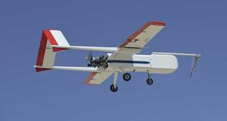
The NASA SIERRA is an uncrewed aircraft system developed by the U.S. Naval Research Laboratory. It is ideal for atmospheric and remote sensing research missions in remote areas such as the Arctic, where flying other aircraft is more hazardous. The SIERRA can carry payloads up to 110 lbs. and reach a maximum altitude of 13,000 ft, enabling more precise data collection.
Related Campaigns & Instruments
Review the instruments operated on this platform for each of these field campaigns
Slide 1 of 2

Characterization of Arctic Sea Ice Experiment
2009
Svalbard archipelago of Norway
view all deployment dates
1 Deployment
· 0 Data Products| 2009-07-13 | 2009-07-29 |
Generic-Atmospheric State (Gen-AtmsState) refers to non-specific instruments on a platform that measure atmospheric state parameters. These are typically in situ sensors that measure temperature, pressure, humidity, and wind speed and direction. Types of atmospheric state instruments include thermometers, hygrometers, barometers, and anemometers.
Earth Science > Atmosphere > Atmospheric Water Vapor
Earth Science > Atmosphere > Atmospheric Pressure
Earth Science > Atmosphere > Atmospheric Water Vapor > Water Vapor Indicators > Humidity
Earth Science > Atmosphere > Atmospheric Temperature > Surface Temperature > Air Temperature
Earth Science > Atmosphere > Atmospheric Winds > Upper Level Winds > Wind Direction
Earth Science > Atmosphere > Atmospheric Winds > Upper Level Winds > Wind Speed
Earth Science > Atmosphere > Atmospheric Pressure > Atmospheric Pressure Measurements
Earth Science > Atmosphere > Atmospheric Winds > Surface Winds > Wind Direction
Earth Science > Atmosphere > Atmospheric Temperature
Earth Science > Atmosphere > Atmospheric Winds > Surface Winds > Wind Speed
Earth Science > Atmosphere > Atmospheric Winds
The Micro Advanced Synthetic Aperture Radar (MicroASAR) is an airborne radar system developed by Brigham Young University (BYU) and Artemis, Inc. It was designed to operate on uncrewed aerial systems (UAS) and small aircraft. It is a C-band (5428.76 MHz) synthetic aperture radar (SAR) that provides radar imagery with a nominal range resolution of 1 m at a 160 MHz bandwidth. MicroASAR can operate at altitudes from 500 to 3000 ft and has a maximum swath width of 300 to 2500 m.
Earth Science > Spectral/engineering > Radar
Earth Science > Spectral/engineering > Radar > Radar Imagery
A pyrometer is a remote-sensing infrared thermometer that measures the temperature of distant objects by detecting their thermal radiation. It can be mounted on aircraft, ground vehicles, or water-based platforms for surface and sea-surface temperature observations. For atmospheric studies, the pyrometer usually operates in the 9.6 to 11.5 µm spectral range and has a temperature range of -25 to 200 degrees Celsius. Pyrometers typically have a response time between 5 milliseconds and 600 seconds.
Earth Science > Oceans > Ocean Temperature > Sea Surface Temperature
Earth Science > Atmosphere > Atmospheric Temperature > Surface Temperature > Skin Temperature
Earth Science > Atmosphere > Atmospheric Temperature > Surface Temperature
Earth Science > Spectral/engineering > Infrared Wavelengths > Brightness Temperature
The CU LIDAR Profilometer and Imaging System (CULPIS) is an airborne lidar mapping system developed at the University of Colorado at Boulder. It is designed to map land and sea ice surface topography and elevation from uncrewed aerial systems (UAS). It consists of a lidar system, an inertial measurement unit (IMU), a global positioning system (GPS), and digital cameras. The lidar system within CULPIS operates at 905 nm and has a measurement rate of 400 Hz. At a flight altitude of 200 m above ground level (AGL) and a flight speed of 30 meters per second, it has a lidar footprint of 60 cm and an along-track spacing of 7.5 cm.
Earth Science > Terrestrial Hydrosphere > Glaciers/ice Sheets > Glacier Topography/ice Sheet Topography
Earth Science > Land Surface > Topography > Terrain Elevation
Earth Science > Cryosphere > Glaciers/ice Sheets > Glacier Topography/ice Sheet Topography
Earth Science > Spectral/engineering > Lidar
Earth Science > Oceans > Sea Ice > Sea Ice Elevation
Earth Science > Land Surface > Topography
Earth Science > Cryosphere > Sea Ice > Sea Ice Elevation
Spectrometers are instruments that separate and analyze the spectral components of a substance. They typically measure electromagnetic radiation that has been reflected, absorbed, or transmitted by a sample. Spectrometers operate across the ultraviolet to infrared spectrum. The most common types include optical, nuclear magnetic resonance, and mass spectrometers. They can be deployed on aircraft, research vessels, vehicles, and other ground-based platforms.
Earth Science > Spectral/engineering > Infrared Wavelengths
Earth Science > Spectral/engineering > Ultraviolet Wavelengths
Earth Science > Spectral/engineering > Visible Wavelengths
Digital cameras provide imagery for research applications. Cameras are mounted on aircraft to collect aerial imagery for mapping and surveying, environmental monitoring, cloud observations, agriculture, geological studies, and other Earth science applications. They are also deployed at field sites to capture visual observations that monitor changes in land cover, vegetation, clouds, air quality, glaciers, and other phenomena.
Earth Science > Spectral/engineering > Visible Wavelengths > Visible Imagery

Marginal Ice Zone Ocean and Ice Observations and Processes Experiment
2013
Southern Beaufort Sea, Prudhoe Bay, Alaska
view all deployment dates
1 Deployment
· 0 Data Products| 2013-07-09 | 2013-08-09 |
The Jade SWIR Thermal IR Camera is an airborne thermal infrared (IR) camera developed by Cedip Infrared Systems. It operates across the shortwave infrared (SWIR) wavelength range (0.8-2.5 μm) to collect infrared imagery. It operates at up to 200 frames per second at full image size (320 x 256). The Jade camera is typically used for thermal analysis, IR radiometry, and topographic research.
Earth Science > Spectral/engineering > Infrared Wavelengths
Earth Science > Spectral/engineering > Infrared Wavelengths > Thermal Infrared
Earth Science > Spectral/engineering > Infrared Wavelengths > Infrared Imagery
A pyrometer is a remote-sensing infrared thermometer that measures the temperature of distant objects by detecting their thermal radiation. It can be mounted on aircraft, ground vehicles, or water-based platforms for surface and sea-surface temperature observations. For atmospheric studies, the pyrometer usually operates in the 9.6 to 11.5 µm spectral range and has a temperature range of -25 to 200 degrees Celsius. Pyrometers typically have a response time between 5 milliseconds and 600 seconds.
Earth Science > Oceans > Ocean Temperature > Sea Surface Temperature
Earth Science > Atmosphere > Atmospheric Temperature > Surface Temperature > Skin Temperature
Earth Science > Atmosphere > Atmospheric Temperature > Surface Temperature
Earth Science > Spectral/engineering > Infrared Wavelengths > Brightness Temperature
The CU LIDAR Profilometer and Imaging System (CULPIS) is an airborne lidar mapping system developed at the University of Colorado at Boulder. It is designed to map land and sea ice surface topography and elevation from uncrewed aerial systems (UAS). It consists of a lidar system, an inertial measurement unit (IMU), a global positioning system (GPS), and digital cameras. The lidar system within CULPIS operates at 905 nm and has a measurement rate of 400 Hz. At a flight altitude of 200 m above ground level (AGL) and a flight speed of 30 meters per second, it has a lidar footprint of 60 cm and an along-track spacing of 7.5 cm.
Earth Science > Terrestrial Hydrosphere > Glaciers/ice Sheets > Glacier Topography/ice Sheet Topography
Earth Science > Land Surface > Topography > Terrain Elevation
Earth Science > Cryosphere > Glaciers/ice Sheets > Glacier Topography/ice Sheet Topography
Earth Science > Spectral/engineering > Lidar
Earth Science > Oceans > Sea Ice > Sea Ice Elevation
Earth Science > Land Surface > Topography
Earth Science > Cryosphere > Sea Ice > Sea Ice Elevation
The Bobcat 29MP Visible Camera is an airborne visible camera developed by Imperx, Inc. It is part of the IcePod instrument suite operated by Lamont-Doherty Earth Observatory (LDEO) of the Earth Institute at Columbia University. It captures visible imagery at a resolution of 6576 x 4384 pixels, a swath width of 1.2 km, and a maximum frame rate of 20 Hz. These images can be used to determine ice concentration, topography, and ice melt.
Earth Science > Spectral/engineering > Visible Wavelengths > Visible Imagery
Digital cameras provide imagery for research applications. Cameras are mounted on aircraft to collect aerial imagery for mapping and surveying, environmental monitoring, cloud observations, agriculture, geological studies, and other Earth science applications. They are also deployed at field sites to capture visual observations that monitor changes in land cover, vegetation, clouds, air quality, glaciers, and other phenomena.
Earth Science > Spectral/engineering > Visible Wavelengths > Visible Imagery
The Ball Experimental Sea Surface Temperature Radiometer (BESST) is an airborne pushbroom imaging radiometer developed by Ball Aerospace. It is a thermal infrared (8-12 μm) radiometer that measures sea surface temperature. BESST has a spatial resolution of 1 meter and a swath width of 200 meters at a flight altitude of 600 meters. It collects 130 frames per data frame, which takes about 53 seconds to complete. BESST was designed for deployment on uncrewed aerial systems (UAS) and small aircraft.
Earth Science > Oceans > Ocean Temperature > Sea Surface Temperature
Earth Science > Spectral/engineering > Infrared Wavelengths > Thermal Infrared
The Digital Mapping System (DMS) was an airborne camera system operated and maintained by the Airborne Sensor Facility (ASF) at NASA Ames Research Center (ARC). It captured high-resolution natural-color and panchromatic images of terrain, which were used to create mosaics and topographic maps. DMS had a cross-track spatial resolution of 10 cm at nadir and a swath width of about 570 meters at an altitude of 1,500 feet. The DMS was well suited to scientific programs that monitor environmental change, assess global change, and respond to natural disasters.
Earth Science > Spectral/engineering > Visible Wavelengths > Visible Imagery
Spectrometers are instruments that separate and analyze the spectral components of a substance. They typically measure electromagnetic radiation that has been reflected, absorbed, or transmitted by a sample. Spectrometers operate across the ultraviolet to infrared spectrum. The most common types include optical, nuclear magnetic resonance, and mass spectrometers. They can be deployed on aircraft, research vessels, vehicles, and other ground-based platforms.
Earth Science > Spectral/engineering > Infrared Wavelengths
Earth Science > Spectral/engineering > Ultraviolet Wavelengths
Earth Science > Spectral/engineering > Visible Wavelengths
Riegl Airborne Laser Scanners are airborne lidar systems produced by Riegl Laser Measurement Systems. They are commonly used for topographic mapping of glacial, agricultural, urban, and geological regions. Operating primarily in the near-infrared wavelength, they can function at altitudes up to about 14,000 feet, with a field of view of approximately 60 to 75 degrees, and measurement rates of around 3 MHz, depending on the lidar system.
Earth Science > Spectral/engineering > Lidar
Earth Science > Spectral/engineering > Lidar > Lidar Backscatter
Earth Science > Spectral/engineering > Lidar > Lidar Waveform
Earth Science > Land Surface > Topography
The Shallow Ice Radar (SIR) is an airborne ice-penetrating radar system operated by the Lamont-Doherty Earth Observatory (LDEO) at Columbia University as part of the IcePod instrument suite. It is a linear frequency-modulated continuous-wave (FMCW) radar that measures ice depth and thickness. SIR can image up to 450 meters below the ice surface and produce detailed images of ice shelf structures at a resolution of 25 centimeters at a nominal flight altitude of 750 meters above ground level. It operates at a center frequency of 2 GHz with a bandwidth of 600 MHz.
Earth Science > Cryosphere > Glaciers/ice Sheets > Ice Shelves
Earth Science > Cryosphere > Snow/ice > Ice Depth/thickness
Earth Science > Cryosphere > Sea Ice > Ice Depth/thickness
Earth Science > Spectral/engineering > Radar
Earth Science > Terrestrial Hydrosphere > Glaciers/ice Sheets > Ice Shelves
SlimSAR is an airborne synthetic aperture radar (SAR) developed by ARTEMIS, Inc., and owned by the SAR Laboratory at Simon Fraser University (SFU). It is designed to operate on small aircraft and uncrewed aerial vehicles (UAVs). It is a multi-frequency SAR that uses a linear-frequency-modulated continuous-wave (LFM-CW) signal to capture radar images. SlimSAR operates in both the L-band (1215-1400 MHz) and X-band (9.35-9.65 GHz). It features a maximum bandwidth of 660 MHz and a resolution of 23 cm.
Earth Science > Spectral/engineering > Radar
Earth Science > Spectral/engineering > Radar > Radar Imagery
A pyranometer is a ground-based or airborne radiation sensor that measures solar irradiance over a hemispherical field of view. It detects the amount of solar energy reaching the surface, capturing both direct and diffuse sunlight. Pyranometers operate across a spectral range of 280-3000 nm. They are most commonly used for solar monitoring, climate research, weather forecasting, agriculture, and energy management.
Earth Science > Atmosphere > Atmospheric Radiation > Solar Irradiance
Earth Science > Atmosphere > Atmospheric Radiation > Solar Radiation
Earth Science > Atmosphere > Atmospheric Radiation